SCERT AP Board 9th Class Social Solutions 2nd Lesson The Natural Realms of the Earth Textbook Questions and Answers.
AP State Syllabus 9th Class Social Studies Solutions 2nd Lesson The Natural Realms of the Earth
9th Class Social Studies 2nd Lesson The Natural Realms of the Earth Textbook Questions and Answers
Improve Your Learning
Question 1.
Fill in the blanks.
a) Hydrosphere is related to …………………….. .
b) Lithosphere is related to …………………….. .
c) Atmosphere is related to …………………….. .
d) Biosphere is related to …………………….. .
Answer:
a) water mass
b) land mass
c) air mass
d) life
Question 2.
Find the odd one out in the context of lithosphere and give reasons for your choice.
Byson gorge; Grand Canyon; Ozone; Thar desert.
Answer:
Out of these four ozone is the odd one.
Reasons:
- Byson gorge and Grand canyon are hilly areas.
- Rivers flow through them.
- Plants and trees are present there.
- Thar desert is a vast sand desert, with no water. It has thorny bushes and some kinds of desert plantations.
- Above three are landforms.
- But Ozone is an inorganic molecule with the chemical formula 03. It is a pale blue gas with a distinctively pungent smell. Ozone’s 03 formula was determined in 1865.
![]()
Question 3.
How is the Lithosphere formed?
Answer:
- The solid crust or the hard top part of the earth is called lithosphere.
- The crust is made up of rocks and minerals and covered with a thick layer of soil.
- It is uneven and has high mountains, plateaus, plains, and very deep basins.
- Many of these features are shaped by internal and external processes.
- The slow movements inside the earth lead to the formation of the crust.
- The sudden movements can damage and lead to changes in landforms.
- The processes originating from the depths of the earth like earthquakes and the volcanic eruptions play important role in shaping the surface of the earth.
- The external sources like wind, water, glaciers, and waves also play prominent role in shaping the lithosphere.
Question 4.
How are the continental plates formed and how are they eventually destroyed?
Answer:
- In the beginning, probably all continents were held together.
- Later the earth’s lithosphere is broken up into several pieces, just like the pieces of a large jigsaw puzzle and thus continental plates formed.
- These pieces, on which all the continents and oceans are actually situated, are called “Plates”.
- They float on soft layer of the mantle.
- There are about seven major plates and several minor plates on the earth.
- As the plates move, they push, pull, slide, rise, sink, bend and break.
- Sometimes one plate meets another, the incoming plate dips under the stable plate.
- In fact the incoming plate actually goes into the mantle of the earth and becomes molten due to the heat of the mantle.
- That is how some plates are eventually destroyed.
Question 5.
List out the landforms formed due to the river work. (AS1)
Answer:
Many landforms are formed due to the work of the river. They are
1. V – shaped valley:
The flow of a river is very swift as it descends the steep slopes and it exerts a great force in cutting the mountain vertically. As a result a deep valley develops, narrow at the bottom and wide at the top. This is called V – shaped valley.
2. Gorge:
Where the rocks are very hard, the river cuts a narrow valley with steep sides called Gorges.
3. Canyon:
A deep valley with steep like slopes and is wider at its top than at the bottom is called a Canyon.
4. A plunge pool:
The water falls with great force and dig out the rock beneath to form a plunge pool.
5. Plain:
When the river is in floods it cuts the soil and when it is not in flood it deposits silt and thus forms vast flood plains.
6. Meanders:
As a result of the deposition by floods the river bed becomes too high, the river constantly changes its course and cuts new path and forms gentle snake like meanders.
7. Ox-bow lakes:
Due to the deposition along the sides of the meanders, the ends of the meander loop comes closer and closer. In the course of time the meander loop cuts off from the river and forms a cut off lake which is called ox-bow lake.
8. Delta:
When a river reaches the sea, the fine material is deposited at its mouth forming a delta (∆).
9. Ozone:
Ozone is an inorganic molecule with the chemical formula 03. It is a pale blue gas with a distinctively pungent smell. Ozone’s 03 formula was determined in 1865.
![]()
Question 6.
Create a table as given below and fill information. And write a small paragraph to explain the similarities and differences you can think of in the context of earth’s external changes, (if there is no information available in the text, leave those columns blank)
| Wind | Water | Glacier | |
| Landform | |||
| Process |
Answer:
Wind:
Wind takes many forms and carries away the surface of the land in the higher places.
Water :
- Water reacts with the chemicals of the rocks and further weakens the rock.
Water acts as moving agent of the earth.
Glacier :
- The ice on these glaciers melt throughout the year and flows to low areas as rivers and streams.
- They also erode, transport and deposit rock materials.
Two forces, weathering and erosion, are constantly at work building up and moving rocks making up the earth’s crust.
Weathering causes rocks to fragment, crack, crumble, or break down physically and chemically.
Erosion loosens and carries away the rock debris formed by weathering. Over time these two forces, working together, change the shape of the land.
Question 7.
Why are Glaciers not found in your surroundings?
Answer:
Glaciers are most commonly found above snow line i.e., regions of high snow fall in winter and cool temperatures in summer. These conditions allow more snow to accumulate on the glacier in the winter that will melt in the summer. This is why most glaciers are found either in mountainous areas or the polar regions.
We are in the state of Andhra Pradesh. It is a semi-arid area and has a predominantly hot and dry climate. Summers start in March, and peak in May with average high temperatures in the 42°C range. A dry, mild winter starts in late November and lasts until early February with little humidity and average temperatures in the 22°C – 23°C range. In such hot and dry conditions glaciers are not formed. So we cannot find glaciers in our surroundings.
Question 8.
How are Beaches formed and name some Beaches?
Answer:
Formation of Beaches:
- Sea water contains sediments like sand, pebbles, etc.
- Beaches form as waves deposit these sediment on the shore.
- The wind pushes these sediments on the shore and inland.
- This creates an area of sand particles finally form a beach.
Names of some beaches :
- Diu Beach
- Manori Beach, Mumbai
- Versova Beach, Mumbai
- Mivamar Beach, Panaji
- Karwar Beach, Karnataka
- Fort Kochi, Cochin
- Kovalam Beach, Trivandrum
- Marina Beach, Chennai
- R.K. Beach, Visakhapatnam
- Chandipur Beach, Odisha.
Question 9.
How is the human lifestyle responsible for extension of deserts?
Answer:
- Desertification can be considered as a set of biological, chemical, and physical processes which converge to create desert-like conditions.
- Desertification is a social problem involving people at all stages as a cause and as victims.
- The anthropogenic (human) causes of desertification are over cultivation, over grazing, deforestation and poor irrigation practices.
- These factors are fuelled by local forces such as poverty and population pressure.
- Increase in temperature leads to drying out of water and it further causes to expansion of deserts.
- Mismanagement of dry land ecosystems by humans can cause desertification.
- Poor land use and overgrazing are significant factors for the expansion of deserts.
- Thus activities of human beings lead to the extension of deserts.
![]()
Question 10.
Find out the order of the landforms for the following.
| Landform | Order of Landform |
| The Himalayan Mountains | II order Landform |
| The Pacific Ocean | |
| Asia Continent | |
| Byson Gorge | |
| Jog waterfall | |
| Rocky mountains | |
| The Indian Ocean | |
| The great rift valley |
Answer:
| Landform | Order of Landform |
| The Himalayan Mountains | II order Landform |
| The Pacific Ocean | 1 order Landform |
| Asia Continent | 1 order Landform |
| Byson Gorge | III order Landform |
| Jog waterfall | III order Landform |
| Rocky mountains | II order Landform |
| The Indian Ocean | 1 order Landform |
| The great rift valley | III order Landform |
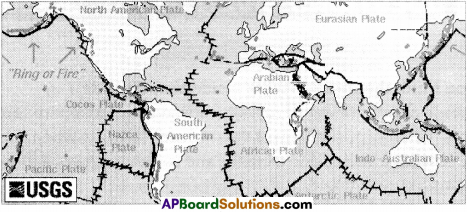
Question 11.
Draw the map of world plates by observing map 2.
Answer:
Question 12.
Read the para under the title ‘Erosion’ on page 20 and comment on it.
| Erosion : Flowing water and wind have great power and can slowly wear away or cut away the rocks and soil cover in higher places. Water acts in many ways, as rain, river, flowing ground water, sea waves, glaciers etc. Wind too takes many forms like storms, gusts, steady winds, etc. The active wearing away of the earth’s surface by these moving agents is called erosion. |
Answer:
Erosion is the process by which soil and rock are removed from the earth’s surface by exogenic processes such as wind or water flow, and then transported andsdeposited on their locations while erosion is a natural process. Human activities have increased by 10 – 40 times the rate of which erosion is occuring globally.
Question 13.
Collect newspaper or magazine articles and news on earthquakes and volcanoes.
Prepare an illustrated file on these – how do they happen and how they affect human life.
Answer:
Student’s activity.
Ex: Earthquakes:
The earth’s surface is formed of massive slabs of rock called plates. These are called tectonic plates, are always moving. Sometimes they just slide past one another. At another time they actually collide with one another. Plate movements cause the build up of tremendous quantities of energy in the rock. When the energy is released, it produces vibrations that travel through the rock, leading to earthquakes. During earthquakes, faults, or giant cracks, are produced by the pressure of moving rocks.
Volcanoes:
Deep within the earth it is so hot that some rocks slowly melt and become a thick flowing substance called magma. Because it is lighter than the solid rock around it, magma rises and collects in magma chambers. Eventually some of the magma pushes through vents and fissures in the earth’s surface. Then a volcanic eruption occurs.
Their effect on human life :
- Major earthquakes and volcano eruption can affect human life.
- Roads can be damaged and delivery of food can be disrupted.
- Clean, drinking water may not be available.
- Sewer system may leave, causing diseases.
- Gas line could leak, causing health issue.
- All the surroundings can get covered with ash.
- Communication system fails.
- They destroy property and threaten human lives.
9th Class Social Studies 2nd Lesson The Natural Realms of the Earth InText Questions and Answers
Question 1.
Why do you think the rock is harder inside than outside? (Text Book Page No. 20)
Answer:
- The gradual disintegration of rocks is caused by atmosphere forces.
- The rocks when exposed to heat expand and contract when cooled down.
- As surface rock contracts and expands and contracts again, it gradually becomes brittle and begins to break down.
- Water reacts with the chemicals in the rock and further weakens it.
- These processes by which the rocks are weakened and broken are called ‘weathering’.
- It is easier to chip small pieces of rock from the outer layer rather than from the core of the rock.
- Thus we can say the rocks are harder inside than outside.
![]()
Question 2.
Expalin how are the waterfalls are useful. (Text Book Page No. 22)
Answer:
- The most noted advantage of waterfalls is their ability to produce hydroelectric power.
- As it descends the steep slopes the waterfall exerts a great force and cuts mountains vertically and forms V-shaped valleys, gorges and canyons.
- These attract many tourists throughout the world and earn a lot of foreign exchange.
- Waterfalls put oxygen into the water which first helps the fish breathe well.
Question 3.
Can you discuss in the class how the following human actions impact the lithosphere?
i) Mining
ii) Building cities with bricks and cement
iii) Agriculture
iv) Dams (Text Book Page No. 25)
(OR)
‘Human actions like mining, building cities with bricks and cement, agriculture and dams are impacting the lithosphere’ – Comment on it. Mra
Answer:
i) Impact of mining on lithosphere :
- Mining disturbs and removes the rocks, ores and minerals in the geosphere.
- It leaves huge gaping holes in the earth.
- The mine tailings are pulled up in large mounds on the surface of the geosphere.
- Subsidence is an effect that occurs above a deep mine.
- The deep mines cause redistribution of the existing tectonic stress field disturbed by the excavation process.
- High stresses exist inside tectonic plates and they are sensitive to any perturbations.
- In case of mining the mass removal causes fault zones and eventually earthquakes.
ii) Impact of building cities with brick and cement on lithosphere:
Constructing buildings with cement and bricks has a lot of negative effects.
- Concrete used to create hard surfaces causes to surface turn off and it can cause heavy soil erosion.
- Constructing the buildings with cement, bricks and concrete have different thermal and hydrological properties. These cause the surface absorbs and stores heat and water.
iii) Impact of agriculture on lithosphere:
Man has been trying to manipulate more and more of nature and exploit this natural resource by the unscientific practice of agriculture.
- Agriculture causes the depletion of underground acquifiers through overdrafting.
- Under irrigation gives poor soil salinity control which leads to increase soil salinity with consequent build up of toxic salts on soil surface.
- Wide use of agricultural chemicals causes soil pollution.
iv) Impact of dams on lithosphere :
- As a result of dam construction and holding of sediments in reservoirs sediment feeding of down stream channel or shore beaches is prevented.
- Corrosions may occur.
- Rare archaeological and historical places with their exceptional beauties disppear after lying under the reservoir.
- Earthquakes and volcanic activity can be induced by the weight of the reservoir on nearby faulty lines.
- Soil erosion of silt deposited at the edges of reservoirs can seriously damage surrounding vegetation and farmland by sand blow.
Question 4.
Write an imaginary description of the damages that occur due to volcanic eruption in an area. (Text Book Page No. 19)
Answer:
- Volcanic eruption can cause earthquakes, fast floods, mudslides and rock falls.
- Lava can travel very far and burn, bury or damage anything in its path including people, houses and trees.
- The large amount of dust and ash can cause roofs to fall, makes it hard to breathe and is normally very smelly.
- The ground around volcano is not secure and can cause big earthquakes.
- Big volcanic eruptions can change the weather around the world.
- Ash clouds float very high in the air and can cause snow and frost in the summer in a lot of countries.
![]()
Question 5.
Compare the Loess Plains with a Delta. What similarities and differences do you see between them? (Text Book Page No. 25)
Answer:
Similarities between Loess Plains and Deltas :
- Both are the deposits of erosional fine materials on plains.
- Both loess plains and deltas are fertile lands.
Differences between Loess Plains and Deltas:
- While loess plains are formed with fine dust blown beyond the deserts, the deltas are formed with fine alluvial material transported by the rivers.
- While loess plains are formed in the neighbouring lands of the deserts, the deltas are formed at the mouths of the rivers.
- While loess are fine loam, rich in lime, very coherent and extremely porous, the deltas consist of clayey alluvial soils with a mixture of organic material.
- While deltas are formed by the action of rivers, the loess plains are formed by the action of winds.
Question 6.
Geologists have found fossils of sea animals on the Himalayas. Some of these are actually worshipped in many homes as ’Salagramas’. How do you think are these^ossil^here on the Himalayas? (Text Book Page No. 17)
Answer:
- The Himalayas are formed by the collision of the Indian and Eurasian land masses which were originally separate.
- This collision uplifts mountains.
- From around 200 million years ago the area between the two separate land masses was covered by the Tethys sea, which was filling with sediments and had sea creatures which left fossils in the sedimentary rocks formed there.
- So the fossils found in the Himalayas are those formed in the ancient sea bed of the Tethys sea, now exposed and pushed up to form mountains.
- Salagramas are usually black coloured spherical fossils found in the sacred river Gandaki.
- The name salagrama refers to the name of the village on the bank of the Gandaki, where the holy stones are picked up.
- Hindus consider these salagramas as an iconic representation of Vishnu and worship these salagramas.
Question 7.
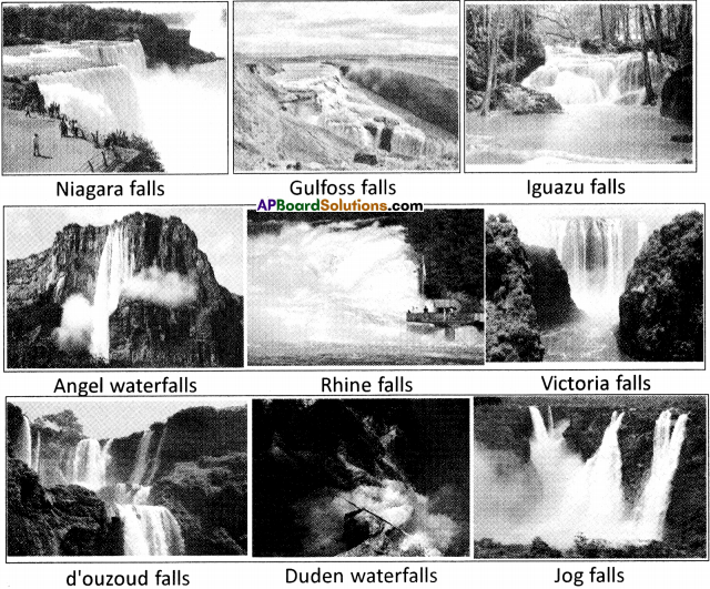
Collect information about the waterfalls in Andhra Pradesh. (Text Book Page No. 22)
Answer:
Waterfalls of Telangana :
- Ethipothala falls, near Nagarjuna Sagar Dam.
- Katiki waterfalls – Visakhapatnam district
- Kailasakona falls – Chittoor district
- Mallelatheertham – Nallamala forest, Kurnool district
- Penchalakona falls – Nellore district
- Rampachodavaram – East Godavari district
- Talakona falls – Chittoor district
- Ubbalamadugu or Tada falls – Chittoor district
![]()
Question 8.
Collect some of the pictures of waterfalls. (Text Book Page No. 22)
Answer:
Pictures of famous waterfalls :
Question 9.
Gorges are suitable for construction of dams- can you tell why this is so? (Text Book Page No. 21)
Answer:
- Gorges are narrow valleys with steep sides.
- A gorge is almost equal in width at its top as well as its bottom.
- They are suitable for the construction of massive reservoirs.
- The natural valleys formed by the gorges are built up with hard rock.
- The valleys with its steep sides, extensive rocky floors form the natural reservoirs for the dams.
- Constructing the dams at gorges is less expensive because a little concrete work is needed to form the reservoirs.
- In these vast and massive reservoirs a lot of water can be stored.
- Gorges are flood proof. They prevent floods.
- The waterfalls that falls down from great heights into the gorges can rotate large turbines and generate hydroelectricity in large quantities.
- Thus gorges are suitable for the construction of dams.
Question 10.
You have read about mining of minerals like baryte or coal. In what ways do you think does mining affects the lithosphere, hydrosphere and atmosphere? (Text Book Page No. 14)
Answer:
- Mining disturbs and removes the rocks, ores and minerals in the lithosphere leaving huge gaping holes in the earth.
- The mine tailings are piled up in large mounds on the surface of the earth.
- Mining waste when washed into the water ways pollutes the hydrosphere.
- Mining causes air pollution to the atmosphere in several ways.
- The mine might also release poisonous gases that were trapped below the surface.
- Mining affects the biosphere by affecting the other three spheres in an indirect way.
Question 11.
Human beings consume a lot of medicines like anti-biotics to cure sickness. How do you think does it affect the lithosphere, hydrosphere and biosphere? (Text Book Page No. 14)
Answer:
- More than 10,000 tonnes of anti biotics are consumed in Europe each year.
- 30%-60% of them passthrough animals and humans unchanged and reach the ocean.
- These antibiotics can affect the marine ecosystems over a long period, with detrimental effects on natural marine communities of bacteria.
- The presence of antibiotics in the marine environment is worrying as it can reach to humans through the consumption of sea food and fish.
- The marine sediments affected by the antibiotics metabolise both nitrogen and carbon which are linked to both eutrophication and climate problems.
Question 12.
What are the dangers of living on the flood plains? (Text Book Page No. 23)
Answer:
- Flood plains are flood prone areas.
- Massive damage can occur during floods in flood plains.
- Homes, automobiles, buildings, historical monuments, graves, sewer systems, bridges and countless other infrastructure can be destroyed.
- Road ways often suffer. High flooding often claims the lives of drowning victims.
- In flood plains during floods there will be lack of clean drinking water which causes illness and epidemics to spread.
- Thus there are a lot of dangers of living on the flood plains.
Question 13.
Locate the Himalayas, Andes and Rockies mountains. Why were they formed in those locations? Suggest reasons. (Text Book Page No. 17)
Answer:
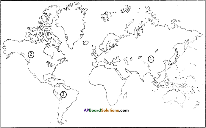
1) Himalayas
2) Rockies mountains
3) Andes mountains
Reasons:
- Fold mountains are mountains formed from the folding of the earth’s crust.
- The Himalayas, the Andes and the Rockies are fold mountains.
- These fold mountains are formed when two plates move together.
- The Himalayan mountains were formed by the process of Indian plate pushing the Eurasian plate.
- The forces of plate tectonics are responsible for the formation of Andes.
- The Nazce plate and a part of the Antarctica plate have been subducting beneath the South American plate.
- The Rockey mountains took shape during an intense period of plate tectonic activity that resulted in much of the rugged landscape of the Western North America.
- The Laramide Orogeny was responsible for raising the Rocky mountains.
![]()
Question 14.
You may have noticed that many of the ‘scientific’ terms use Greek words. Why do you think do they use Greek words? Discuss with your teacher. (Text Book Page No. 14)
Answer:
In his communication a scientist is mainly concerned with exact and logical expression of that which he wishes to pass on to another. His purpose is to inform as clearly as possible. Each of his words must have a precise meaning and one meaning only so that there is no risk of confusion or ambiguity. The meanings of many ordinary words of our language are not single and precise. The use of words which are ‘set apart’ from everyday life also enables the scientist to avoid evoking irrelevant and distorting associations.
In addition to precision of meaning and freedom from associations most scientific words by their form and structure they reveal something of their meanings. Many scientific words are built from simpler word-elements usually of Greek origin. Some words are self-explanatory if the Greek roots are known.
Scientific language to be efficient must be universally intelligible. The classical language Greek is so fundamental to the civilised world. The words constructed from this language can easily be learnt to be translated.
So scientific terms use Greek words.
Question 14.
Are all rocks on the earth formed in the mid-ocean ridges? (Text Book Page No. 17)
Answer:
No. All the rocks on the earth are not formed in the mid-ocean ridges. Only ocean rocks or crust are formed of the mid-ocean ridges. These are formed by lava rising up from the mantle. The eruptions on the ridges create new ocean floor made of basalt rocks, which then spreads laterally from the ridge. The first order landforms such as oceans and continents are formed at the time when the hot earth was cooling. While the earth’s interior continued to cool, it contracted and the outer crust wrinkled forming ridges i.e., mountains and basins i.e., oceans. The second order landforms such as plains, plateaus and mountains are formed as a result of the internal processes of the earth. The third order landforms such as carved mountains, valleys, deltas, sand dunes are formed as a result of the shaping of the land forms by wind, water.
Question 15.
Why do you think we don’t feel any of these mighty changes taking place on the earth? Is it because they don’t affect us? Do you think these changes affect us at all? (Text Book Page No. 17)
Answer:
- Two kinds of changes take place in the Lithosphere – first the very slow movements leading to the formation of the crust, movement of the continental plates and their eventual return to the mantle.
- Since these geophysical changes occur over thousands and even millions of years we don’t feel any of these changes.
- Secondly the sudden and dramatic eruption of volcanoes and earthquakes.
- The sudden movements can be destructive and cause much damage. At the same time they also lead to changes in landforms.
Question 16.
Compare the action of the river in the mountains and in the plains. In what ways are they similar and different?
Answer:
Similarities :
- They carry something when they flow across the two landforms.
- They have streams in both the areas.
- They change the surface of the earth.
Differences
| In the mountains | In the plains |
| 1. Rivers originate in mountains. | 1. Rivers run and flow across the plains. |
| 2. They flow very fast. | 2. They flow slowly. |
| 3. They carry the rocks. | 3. They deposit the sediments here. |
| 4. They form gorges and canyons here. | 4. They form deltas here. |
From the mountains to delta, a river does not just flow – it changes the surface of the earth.
It cuts rocks, moves boulders, and deposits sediments.
It constantly attempts to carve away all the mountains in its path.
The goal of the river is to create a wide, flat valley which it can flow smoothly towards the ocean.
That is the relation between the mountains and plains.
![]()
Question 17.
Why is a flood plain more suited to human habitation compared to mountains? (Text Book Page No. 23)
Answer:
Disadvantages of mountains :
- High elevation on mountains produces colder climates than at sea level.
- These colder climates strongly affect the human habitation.
- Climate of mountains to be used less for agriculture.
- Abundant water supply.
- Fertile land – rich for farming and agriculture.
- Easy to develop than hilly regions.
- Flood water can be stored temporarily.
- Many civilizations are flourished on the banks of the rivers.
These are all more suited to human habitation compared to mountains.
Question 18.
Recall the life of people living in the hills or flood plains that you may have read of. (Text Book Page No. 23)
Answer:
Bison hills are spread in both Bhadradri Kothagudem and W. Godavari districts along either banks of the river Godavari. Many tribal communities live in the hill tracts of this region with their own special life.
These tribals live in small habitations – about 5 to 10 hutments in one place. The habitations are far from each other.
Konda Reddys grow crops in a distinct way called Podu. When rains arrive in June they dibble seeds with the help of digging seeds.
Except for a few months during and after harvest, Konda Reddy women and children are engaged in collection of edible forest produce for subsistence.
There are no rivers or wells in this area. They fetch water from natural springs.
These hill tribes are very few in number but they follow a pattern of life which is very ancient.