SCERT AP Board 8th Class Social Solutions 1st Lesson Reading and Analysis of Maps Textbook Questions and Answers.
AP State Syllabus 8th Class Social Studies Solutions 1st Lesson Reading and Analysis of Maps
8th Class Social Studies 1st Lesson Reading and Analysis of Maps Textbook Questions and Answers
![]()
Question 1.
Study the school atlas carefully by looking at various thematic maps.
Answer:
Self-exercise.
Question 2.
Do you think the use of maps has changed between the time of ancient Greeks and now? In what way is it similar and different?
| in ancient Greece | Now | |
| Similarities | ||
| Differences |
Answer:
Yes, I think so.
| In ancient Greece | Now | |
| Similarities | They tried to make the maps accurate with the help of longitudes and latitudes. | The maps are very accurate and detailed with the help of satellites. |
| Differences | Maps were made to help the sailor. | Maps are used extensively for planning, development of countries. |
![]()
Question 3.
Many people believe that making of maps by the Colonial powers was a more powerful tool for exploitation and control of the colonies than guns. Do you agree? Why?
Answer:
Yes, 1 agree with the given statement.
The reasons are –
- When European powers coionised the entire continents like North and South Americas, Africa, Australia and Asia they needed to know about the places, their climate, crops, mineral resources and about the people living there.
- They sent scientific expeditions consisting of map makers and others to explore the different parts of the world and prepare maps.
- These teams fought their way into interiors of continents crossing mountains, deserts and rivers, fighting local peoples to get the necessary information. ,
- This information and the maps enabled the colonial powers to establish their rule over these areas and also exploit their resources.
Question 4.
In what ways were the maps prepared by the British different from the one made by Ptolemy or Idrisi?
Answer:
| British maps | Maps of Ptolemy or idrisi |
| 1. They prepared maps to establish their rule over the areas and .also exploit their resources. | 1. They prepared their maps for their kings and their interests. |
| 2. These maps give more information of their colonies. | 2. These maps give more correct information of Europe and nearby countries. |
| 3. These are relevant to present day maps. | 3. They show their continents in the centre of the earth. |
| 4. These show the north towards the top of the map. | 4. Al-Idrisi’s map shows the south towards the top of the map. |
![]()
Question 5.
Read the text the “Use of maps in our times” and answer the following question:
As we saw above, maps were made and used for a variety of purposes: for trade, sailing, for conquests and colonising and for fighting wars. In our own times maps are used extensively for planning, development of countries. This requires planners to identify the problems faced by a region and its resources etc. This is done with the help of maps. For example, we can make a map of regions which have very little drinking -water. We can compare this map with maps showing water resources – rainfall, groundwater and rivers. Based on this comparison we can decide what is the best way to make drinking water available to all the people of the region – by sinking tube wells, or building dams across streams or making tanks (cheruvus) or bringing water from distant places in large pipes. Similarly, we can plan agricultural development, setting up new industries, building roads, hospitals and schools with the help of maps.
What are the various purposes for which maps are used in our times?
Answer:
- In our own times maps are used extensively for planning and development of countries.
- We can plan agricultural development, setting up new industries, buildings, roads,
hospitals and schools with the help of maps. - Maps are also used by companies to plan their business work.
![]()
Question 6.
Prepare a few questions to know about different types of maps.
Answer:
- How many kinds of maps are there?
- What are different kinds of maps?
- What are thematic maps?
- What are political maps?
- What do the physical maps show?
- Which kind of maps show information about the climate of an area?
- What are road maps?
8th Class Social Studies 1st Lesson Reading and Analysis of Maps InText Questions and Answers
Question 1.
In what ways do you think the sailors influenced the making of maps in early times?
(Textbook Page No. 6)
Answer:
The sailors travelled widely and wrote down descriptions of the land and people and their histories they saw or heard about. They prepared maps based on these travels and descriptions. Though these maps have not survived, historians have tried to recreate them with the help of their descriptions.
Question 2.
Do you think this free access to maps is a good thing? Why? (Textbook Page No. 8)
Answer:
No, I do not think so. Any government has to maintain secrecy in access to maps. Otherwise it helps the enemies. But at present satellite images reveal every place on the earth.
![]()
Question 3.
If someone wants to choose an appropriate place to set up a hospital, what kind of maps would be useful to her? Make a list.
Answer:
- Map showing hospitals
- Map showing laboratories
- Map showing scanning centres
- Map showing ill-health
- Map showing bus routes
- Map showing train routes and
- Map showing blood banks.
Question 4.
Can you suggest how maps can be used to plan setting up new schools and colleges? What different kinds of maps would have to be studied for this? (Textbook Page No. 8)
Answer:
One has to observe the following matters to establish educational institutions.
- School going children or college going youth.
- Up locations of their schools and colleges.
- Their distances
- Area/land for establishing the institution.
- Their financial status for fees determination, etc.
For this one has to Study
- Population map
- Residential area map
- Transport map
- Water facilities map, etc.
![]()
Question 5.
Find out about the lives of some of the great explorers like David Livingstone, Stanley, Amundsan, etc. Find out who sponsored their expeditions and why? (Textbook Page No. 8)
Answer:
a) David Livingstone: 19-3-1813 to 1-5-1873 – Scotland – UK – Explored Africa. Sponsored by London Missionary Society.
To develop trade and spread of Christianity
b) Sir Henry Morton Stanley : 28-1-1841 to 10-5-1904 – Denbigh – Wales – UK. Sponsored by New York Herald – To find David Livingstone.
c) Roald Amundsan: 16-7-1872 to 18-6-1928 – Borge – Ostfold – Norway.
Sponsored by Belgian Antarctic expedition – To discover the South pole.
d) Alfonsa – De – Albuquerque: 1453 to 16-12-1515 – Portuguese Sponsored by King Manuel I of Portugal.
To establish Portuguese colonial empire in the Indian Ocean.
Question 6.
Why do you think the map makers place their own country in the middle of the map? (Textbook Page No. 6)
Answer:
The map makers in the olden days were mostly depended on the books written by sailors. They were really patriots. They thought that their country was centre of the world and most important in the world. So they placed their own country in the middle of the map.
Question 7.
Why do you think the colonial powers invested so much money to prepare detailed maps? (Textbook Page No. 8)
Answer:
The information from the maps and map makers enabled the colonial powers to establish their rule over their colonies and also exploit their resources. So the colonial powers invested so much money to prepare detailed maps.
![]()
Question 8.
Why do you think maps are useful to armies in times of war? (Textbook Page No. 8)
Answer:
Maps were also in great demand during times of war as armies and airforces needed them.
They use strategy maps to illustrate an organization’s vision, mission, overarching strategies and key goals and initiatives.
Question 9.
Can you guess why? Can you locate India and Srilanka (which was shown much bigger that it is)? (Textbook Page No. 4)
Answer:
Peninsular India is-pushed into the northern India in Al Idrisi’s map. The coast has become more east-west aligned. The Deccan is surrounded on two sides of coasts running North- South ending in sharp point, Cape Comorin.
Sri Lanka is shown much bigger than it is. So it is not easy to locate India and Sri Lanka in Al Idrisi’s map. But I will try.
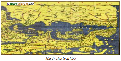 Note: To read this map we should turn it upside down.
Question 10.
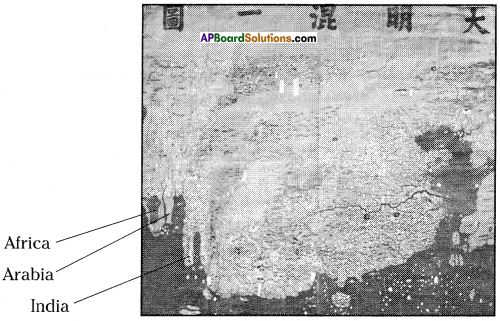
Can you identify India, Arabia and Africa in map (Map of Da Ming Hun Yi Tu of China)? (Textbook Page No. 5)
 Answer:
In this map India, Arabia and Africa were mapped from an Indian Ocean perspective. They are mis-shaped. They are on the bottom of left side of the map.