Practice the AP 8th Class Social Bits with Answers Chapter 1 Reading and Analysis of Maps on a regular basis so that you can attempt exams with utmost confidence.
AP State Syllabus 8th Class Social Bits 1st Lesson Reading and Analysis of Maps with Answers
Choose the correct answer.
Question 1.
Anaximander was a ……………. geographer.
A) Greek
B) Italian
C) Indian
D) Canadian
Answer:
A) Greek
Question 2.
One famous Arab mapmaker, Al Idrisi prepared a ………………… map for his king.
A) Arab
B) Indian
C) World
D) Australia
Answer:
C) World
![]()
Question 3.
Relief features mean the high and low places on the surface of a
A) Planet
B) Star
C) Ocean
D) Core of a star
Answer:
A) Planet
Question 4.
An/A is a collection of maps.
A) Mapbook
B) Atlas
C) Textbook
D) Notebook
Answer:
B) Atlas
Question 5.
They established a department called “Survey of India.”
A) Dutch
B) French
C) British
D) Polish
Answer:
C) British
Question 6.
In ……………. William Hambton began one of the most important geographical surveys in the world.
A) 1802
B) 1702
C) 1902
D) 1752
Answer:
C) 1902
![]()
Question 7.
A map is used by geographers to show features and information that we consider important about a place.
A) Political maps
B) Geographical maps
C) Historical maps
D) None
Answer:
A) Political maps
Question 8.
Some of the earliest surviving maps were made about …………… years ago.
A) 2000
B) 3000
C) 4000
D) 5000
Answer:
C) 4000
Question 9.
……………. also made some of the world earliest maps.
A) Sumerians
B) Babylonians
C) Chinese
D) Indians
Answer:
B) Babylonians
Question 10.
They tried to make the maps accurate with the help of longitudes and latitudes.
A) Romans
B) Persians
C) Greeks
D) Indians
Answer:
C) Greeks
![]()
Question 11.
A set of places where the midday occurred at the same time were joined together with a line from North to South is
A) Meridian
B) Noon-line
C) Longitude
D) All the above
Answer:
D) All the above
Question 12.
The Chinese showed this cape which was already discovered by the Europeans
A) Kanya Kumari
B) Goodhope
C) Biskae
D) All the above
Answer:
B) Goodhope
Question 13.
The birthplace of Jesus Christ
A) Palestine
B) Jerusalem
C) Arabia
D) America
Answer:
B) Jerusalem
![]()
Question 14.
The Europeans rediscovered the books of Ptolemy in
A) 1400
B) 1480
C) 1520
D) 1600
Answer:
B) 1480
Question 15.
The …………… had blocked the trade route to India across the Mediterranean sea.
A) Arabs
B) Europeans
C) Turks
D) Greeks
Answer:
A) Arabs
Question 16.
……………. discovered America.
A) Columbus
B) Vasco-da-Gama
C) Magillan
D) Copernicus
Answer:
A) Columbus
Question 17.
In the 16th century ……………….. emerged as a major trading power.
A) Holland
B) Poland
C) Russia
D) Spain
Answer:
A) Holland
![]()
Question 18.
……………. was appointed as Indian Surveyor General.
A) James Rennel
B) James Sanneel
C) James William
D) None
Answer:
A) James Rennel
Question 19.
In our times …………….. are used extensively for planning and development of countries.
A) maps
B) pictures
C) cinemas
D) statues
Answer:
A) maps
Question 20.
Usually, a map focuses only on one aspect which is called as …………….. maps.
A) thematic
B) geographical
C) employment
D) population
Answer:
A) thematic
Question 21.
This colour is used to show the forest in a map.
A) light green
B) dark green
C) wheat colour
D) violet
Answer:
B) dark green
![]()
Question 22.
The colour is used to show mountains in maps.
A) violet
B) dark violet
C) light violet
D) dark grey
Answer:
D) dark grey
Question 23.
……………. is used to show tanks, rivers, canals and wells, etc.in maps.
A) Light red
B) Light violet
C) Light blue
D) White
Answer:
C) Light blue
Question 24.
The other name of contour lines.
A) Isobars
B) Isohyets
C) Isolines
D) Isopleths
Answer:
C) Isolines
Question 25.
A science of maps
A) History
B) Cartography
C) Coreography
D) All the above
Answer:
B) Cartography
![]()
Question 26.
The Britishers established a department to prepare detailed maps of the interiors of the country. (
A) Indian Forest Department
B) Indian River-based Department
C) Survey of India
D) Indian Soil Department
Answer:
C) Survey of India
Question 27.
……………. is the technique of taking of photographs of the ground from an elevated position using aircrafts, helicopters, hot air balloons, etc.
A) Aerial line
B) Aerial clouds
C) Aerial photography
D) Sea surface
Answer:
C) Aerial photography
Question 28.
Columbus went ……………. and discovered America.
A) Eastward
B) Westward
C) Southward
D) Northward
Answer:
B) Westward
Question 29.
How did the Greeks show the continents in the world?
A) Europe, Libya, Asia
B) Europe, America, Africa
C) Europe, Asia, America
D) Asia, Libya, America
Answer:
A) Europe, Libya, Asia
![]()
Question 30.
………………. are the photographs of the earth taken by the artificial satellites launched into the space.
A) Satellite imageries
B) Blue colour imageries
C) Drawn by hand
D) None
Answer:
A) Satellite imageries
Question 31.
The maps which show hills, rivers and plateaus.
A) Geographical maps
B) Political maps
C) Economic maps
D) Population maps
Answer:
A) Geographical maps
Question 32.
Babylonians and Sumerians belonged to present day
A) Iran
B) Iraq
C) Russia
D) America
Answer:
B) Iraq
Question 33.
The symbols on a map to show Post Office, Telegraph Office, Combined Office and Police Station in a line.
A) PO TO PTO PS
B) PO RS GS PS
C) CH PO TO PTO
D) RF PF CH CG
Answer:
A) PO TO PTO PS
![]()
Question 34.
The symbol to show roads.
Answer:
A)
Question 35.
The symbols used to show ups and downs, i.e. hills, valleys, plateaus, gardens, river flowing regions on land, lands of stones and sand.
A) contour lines
B) canal lines
C) painting lines
D) all the above
Answer:
A) contour lines
Observe the given map and answer the following questions.
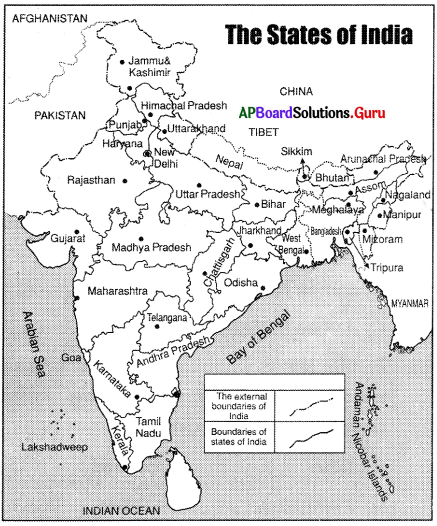
Question 36.
Lakshadweep islands are in,
A) Indian ocean
B) Bay of Bengal
C) Arabian sea
D) Pacific ocean
Answer:
C) Arabian sea
![]()
Question 37.
Andaman Nicobar islands are in
A) Pacific ocean
B) Bay of Bengal
C) Arabian sea
D) Indian ocean
Answer:
B) Bay of Bengal
Question 38.
The state on the east coast among the following
A) Gujarat
B) Bihar
C) Karnataka
D) Andhra Pradesh
Answer:
D) Andhra Pradesh
Question 39.
The state on the west coast among the following
A) Maharashtra
B) Odisha
C) West Bengal
D) Tamil Nadu
Answer:
A) Maharashtra
Question 40.
The state which is not located on the east coast
A) Tamil Nadu
B) Gujarat
C) Andhra Pradesh
D) Odisha
Answer:
B) Gujarat
![]()
Observe the following map and answer the questions.
Question 41.
What type of soil do you find in the Kurnool district?
A) Red
B) Black
C) Alluvial
D) Laterite
Answer:
B) Black
Question 42.
What is the major type of soil in AP?
A) Black
B) Red
C) Laterite
D) Mountain
Answer:
B) Red
Question 43.
What type of soil do you find in Visakhapatnam?
A) Sandy coastal
B) Rocky hill
C) Black
D) None
Answer:
A) Sandy coastal
![]()
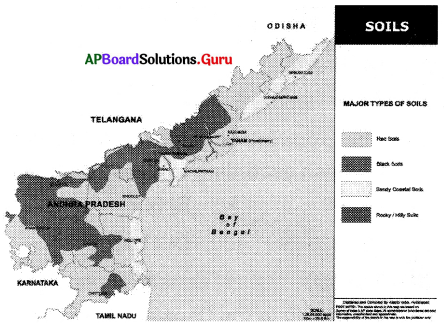
Observe the given map and answer the following questions.
Question 44.
The district which receives low rainfall among the following
A) East Godavari
B) West Godavari
C) Nellore
D) Ananthapur
Answer:
D) Ananthapur
Question 45.
The district which receives high rainfall among the following
A) Ananthapur
B) Kadapa
C) West Godavari
D) Chittoor
Answer:
C) West Godavari
Question 46.
The district which receives moderate rainfall among the following
A) Krishna
B) Guntur
C) Prakasam
D) All the above
Answer:
D) All the above
![]()
Question 47.
Chittoor district receives this type of rainfall
A) high
B) moderate
C) low
D) none of the above
Answer:
B) moderate
Question 48.
East Godavari receives this type of rainfall
A) low
B) moderate
C) high
D) none of the above
Answer:
C) high
Question 49.
The father of cartography was Gerardus Mercator.
A) Iran
B) Indian
C) Greek
D) Dutch
Answer:
D) Dutch
Question 50.
The earliest maps were made by
A) Sumerians
B) Egyptians
C) Chinese
D) Indians
Answer:
A) Sumerians
![]()
Question 51.
The Greek king came to India to conquer the world 2300 years ago.
A) Socrates
B) Alexander
C) Syrus
D) Darius -1
Answer:
B) Alexander
Question 52.
Preparing latitudes and longitudes took about ……………… years.
A) 1000
B) 2000
C) 3000
D) 4000
Answer:
B) 2000
Question 53.
……………… was one of the most famous geographers of the ancient world.
A) Ptolemy
B) Locke
C) Rousseau
D) Syrus
Answer:
A) Ptolemy
Question 54.
The books were used by the Arab scholars and sailors to prepare maps.
A) Copernicus
B) Galileo
C) Ptolemy
D) All the above
Answer:
C) Ptolemy
![]()
Question 55.
…………….. prepared a world map for his king in 1154.
A) Al idrisi
B) Ptolemy
C) Locke
D) None
Answer:
A) Al idrisi
Question 56.
During the 15th century, …………….. inspired a new enthusiasm in the non-Arabic world.
A) Copernicus
B) Ptolemy
C) Al Idrisi
D) Locke
Answer:
B) Ptolemy
Question 57.
The Father of Dutch Cartography
A) Galileo
B) Gerardus Mercator
C) Al Idrisi
D) Copernicus
Answer:
B) Gerardus Mercator
Question 58.
He/who prepared one of the first survey-based maps of India.
A) Sir William
B) Mecauley
C) James Rennel
D) James -1
Answer:
C) James Rennel
![]()
Question 59.
This person proved that Everest is the highest peak in the world.
A) Sir George William
B) Me. Mahon
C) Durand
D) Sir George Everest
Answer:
D) Sir George Everest
Question 60.
The population density of Andhra Pradesh according to Census – 2011 is
A) 308
B) 307
C) 1030
D) 1102
Answer:
D) 1102
Question 61.
The state highest density of population according to the Census – 2011.
A) Assam
B) Kerala
C) West Bengal
D) Bihar
Answer:
D) Bihar
![]()
Question 62.
The population density of West Bengal
A) 1102
B) 1030
C) 859
D) 828
Answer:
B) 1030