Practice the AP 7th Class Social Bits with Answers Chapter 1 Reading Maps of Different Kinds on a regular basis so that you can attempt exams with utmost confidence.
AP State Syllabus 7th Class Social Bits 1st Lesson Reading Maps of Different Kinds with Answers
Choose the correct answer.
Question 1.
Maps showing the distribution of forests are
A) Physical Map
B) Thematic Map
C) Atlas
D) Political Map
Answer:
A) Physical Map
Question 2.
The blue colour is used for showing
A) Waterbodies
B) Mountains
C) Plains
D) Hills
Answer:
A) Waterbodies
![]()
Question 3.
Maps are of
A) two types
B) many types
C) some types
D) four types
Answer:
B) many types
Question 4.
………….. is a line joining the places with equal heights.
A) Contour line
B) Plain
C) Hill
D) Plan
Answer:
A) Contour line
Question 5.
…………….. is cut by many rivers like the Krishna and the Godavari which form deep and broad valleys in them.
A) The hill
B) The plain
C) The plateau
D) The mountain
Answer:
A) The hill
![]()
Question 6.
…………. tell us about how high or low the places are.
A) Maps
B) Globes
C) Plans
D) Books
Answer:
A) Maps
Question 7.
PO stands for
A) Police Officer
B) Post Office
C) Polling Officer
D) Post and Telegraph Office
Answer:
B) Post Office
Question 8.
![]() This is the symbol of ……………….
This is the symbol of ……………….
A) Tank
B) River
C) Borewell
D) Canal
Answer:
A) Tank
Question 9.
![]() This is the symbol of
This is the symbol of
A) Settlement
B) Graveyard
C) Trees
D) Clouds
Answer:
B) Graveyard
![]()
Question 10.
To show any physical features on a map, we can use these
A) heights/ups
B) downs
C) symbols
D) all the above
Answer:
C) symbols
Question 11.
Delhi can be shown with this
A) (•) Dot
B) ( ~ ) Flowway
C) ![]() Track
Track
D) Border with different colors
Answer:
A) (•) Dot
Question 12.
The heights on the earth are measured from this
A) lakes
B) sea level
C) rivers
D) river flows
Answer:
B) sea level
Question 13.
This joins the places with equal heights on the map
A) Contour lines
B) Flatlines
C) Both A & B
D) None
Answer:
C) Both A & B
Question 14.
Contour lines
A) crosses each other
B) do not cross each other
C) irregular in shape
D) both B & C
Answer:
D) both B & C
![]()
Question 15.
If the Slope of land is gentle
A) the contour lines will be quite far from each other.
B) the contour lines will be very near.
C) the contour lines will be at different heights.
D) none
Answer:
A) the contour lines will be quite far from each other.
Question 16.
The distance between two contour lines depends upon the landscape of this
A) earth
B) mountain
C) sea
D) water
Answer:
A) earth
Question 17.
If we observe the Andhra Pradesh map the river Godavari flows in this direction.
A) East
B) West
C) North
D) South
Answer:
A) East
Question 18.
These rivers divide the Andhra Pradesh Plateau region.
A) Penna, Kaveri
B) Krishna, Tungabhadra
C) Krishna, Godavari
D) Narmada, Tapathi
Answer:
C) Krishna, Godavari
Question 19.
The use of maps
A) to lay down roads
B) to find out the submerged lands due to dams.
C) both A & B
D) none
Answer:
C) both A & B
![]()
Question 20.
To measure the sea level this will foe taken as consideration.
A) the average height of tides
B) they observe the height of average tides and calculate the average sea level,
C) by taking the surface of the tides into consideration
D) both A & B
Answer:
D) both A & B
Question 21.
This picture shows

A) Antarctica
B) Himalayas
C) Arctic region
D) Magnolia
Answer:
A) Antarctica
Question 22.
 This is the symbol of
A) Tank
B) River
C) Temple
D) Well
Answer:
B) River
Question 23.
 This is the symbol of
A) Borewell
B) River
C) Tank
D) Canal
Answer:
A) Borewell
![]()
Question 24.
Name the city which is the common capital of two Northern states,
A) Delhi
B) Gandhi Nagar
C) Chandigarh
D) Kolkata
Answer:
C) Chandigarh
Question 25.
Mention one state which shares a boundary with three seas.
A) Kerala
B) Tamilnadu
C) Gujarat
D) West Bengal
Answer:
B) Tamilnadu
Question 26.
Mention one eastern state which has coast and boundary with the neighboring country
A) Nagaland
B) Sikkim
C) West Bengal
D) Odisa
Answer:
C) West Bengal
![]()
Question 27.
All heights on the land are calculated from
A) Sea level
B) Land level
C) Atmospheric level
D) Ground level
Answer:
A) Sea level
Question 28.
A contour line is joining two places M and N. The height of M is 50 meters. Then the height of N is
A) 150 meters
B) 100 meters
C) 50 meters
D) 25 meters
Answer:
C) 50 meters
Question 29.
………….. maps show a variety of landforms and depict the height of places.
A) Political
B) Thematic
C) Physical
D) Atlas
Answer:
C) Physical
Question 30.
A contour line is a line joining the places with equal …………
A) Rainfall
B) Temperature
C) Climate
D) Height
Answer:
D) Height
Question 31.
Which of the cities shown on the map has better opportunities for economic development?
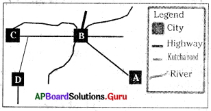
A) City A
B) City B
C) City C
D) City D
Answer:
B) City B
![]()
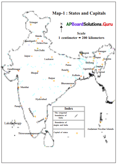
Answer questions 32 and 33 based on the map given below.
Question 32.
If the distance between Bangalore and Mumbai; in the Map is 5 cm, then what Is the actual distance between Bangalore and Mumbai?
A) 5 km
B) 5 cm
C) 200 km
D) 1000 km
Answer:
D) 1000 km
Question 33.
Adil went to Delhi from Amaravathi. In which direction did he travel?
A) South
B) North
C) West
D) East.
Answer:
B) North
![]()
Question 34.
The heights of a place can be measured based on this
A) Origin place of river
B) Interior of Sea
C) Foothill
D) Mean Sea level
Answer:
D) Mean Sea level
Question 35.
A contour line is joining two places M and N. The height of M is 50 meters. Then the height of N is:
A) 150 meters
B) 100 meters
C) 50 meters
D) 25
Answer:
C) 50 meters
Answer questions 36 and 37 based on the map given below.
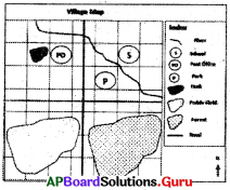
Question 36.
Which of the following information is missing from the map?
A) Index
B) Scale
C) Directions
D) Title
Answer:
B) Scale
![]()
Question 37.
The post office is located on which side of the pond?
A) North
B) East
C) South
D) West
Answer:
D) West
Answer questions 38 and 39 based on the map given below.
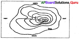
Question 38.
If the contour interval of the map is 10 meters, what is the elevation at the point F?
A) 10 meters
B) 20 meters
C) 30 meters
D) 40 meters
Answer:
D) 40 meters
![]()
Question 39.
Which is the steepest slope on the hill?
A) North
B) East
C) South
D) West
Answer:
D) West