Practice the AP 10th Class Social Bits with Answers Chapter 1 India: Relief Features on a regular basis so that you can attempt exams with utmost confidence.
AP State Syllabus 10th Class Social Bits 1st Lesson India: Relief Features with Answers
Question 1.
The highest peak in Eastern Ghats
A) Anaimudi
B) DodaBetta
C) Gursikhar
D) Aroya Konda
Answer:
D) Aroya Konda
Question 2.
The latitude that does NOT pass through India.
A) 8° N.L.
B) 48° N.L.
C) 12° N.L.
D) 36° N.L.
Answer:
B) 48° N.L.
Question 3.
The latitude that passes through India
A) Equator
B) Tropic of Capricorn
C) 36°N
D) Tropic of Cancer
Answer:
D) Tropic of Cancer
![]()
Question 4.
The difference between the Greenwich Mean Time and the Indian Standard Time is
A) -4.30 minutes
B) -5.30 minutes
C) +4.30 minutes
D) +5.30 minutes
Answer:
D) + 5.30 minutes
Question 5.
Which of the following statements is wrong
A) India has a longitudinal extent of 30°.
B) The average height of Himadri range is 6,100 mts.
C) The Palk Strait separates Pakistan from India.
D) The west coastal plain has no lakes.
Answer:
C) The Palk Strait separates Pakistan from India.
Question 6.
The distance between North and South extremes of India is …………………
A) 2933 kms
B) 15,200 kms
C) 7516.6 kms
D) 3214 kms
Answer:
D) 3214 kms
Question 7.
The Pirpanjal ranges are situated in this region.
A) Greater Himalayas
B) Lesser Himalayas
C) Shivalik ranges
D) Purvanchal
Answer:
B) Lesser Himalayas
Question 8.
The Mawkdok Dympep valley is present in the state shown with the number
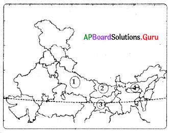
A) 1
B) 2
C) 3
D) 4
Answer:
D) 4
Question 9.
Of the following which is not true?
A) Bhabar is porous in nature
B) Chotanagpur is rich in mineral resources
C) Mahadev ranges are on the east side of Deccan plateau
D) Arkan yoma is a river in Myanmar
Answer:
D) Arkan yoma is a river in Myanmar
Question 10.
Lakshadweep islands are located in one of the following
A) Bay of Bengal
B) Arabian Sea
C) Pacific Ocean
D) Indian Ocean
Answer:
B) Arabian Sea
![]()
Question 11.
The central highlands (Malwa plateau) and the Deccan plateau are the parts of one of the following.
A) Indian peninsular plateau
B) The land stretching between Himalayas and Vindhya mountains
C) Northeastern part of India
D) Thar desert area
Answer:
A) Indian peninsular plateau
Question 12.
The southernmost tip of India is found in Nicobar island and called ………………….
A) Nariman point
B) Rajiv Gandhi point
C) Nehru point
D) Indira point
Answer:
D) Indira point
Question 13.
The Shivaliks in Assom are known as …………..
A) Cachar
B) Jammu hills
C) Mishmi hills
D) Mizo
Answer:
A) Cachar
Question 14.
The portion of triangular shaped
peninsular plateau lying to the south of river Narmada is called as ………………..
A) Chotanagpur plateau
B) Tibet plateau
C) Deccan plateau
D) Malwa plateau
Answer:
C) Deccan plateau
Question 15.
The longest canal in the country watering part of Thar desert in Rajasthan is ………………
A) Buckingham canal
B) Mayurakshi canal
C) Ken canal
D) Indira canal
Answer:
D) Indira canal
Question 16.
In Andaman and Nicobar, the origin of Narcondam and Barren Islands is from ………………..
A) Volcanoes
B) Rivers
C) Mountains
D) Hills
Answer:
A) Volcanoes
Question 17.
The land extended from river Ghaggar to Teesta is ……………………
A) Sindhu plain
B) Ganga plain
C) North plain
D) South plain
Answer:
B) Ganga plain
Question 18.
The Indian peninsula was a part of ………………….
A) Angara landmass
B) Deccan plateau
C) Thar desert
D) Gondwana land
Answer:
D) Gondwana land
![]()
Question 19.
The famous valley of Kashmir is situated between the mountain ranges of
A) Karakoram and Ladakh
B) Ladakh and Zaskar
C) Zaskar and Greater Himalayas
D) Greater Himalayas and Birpanjal
Answer:
D) Greater Himalayas and Pirpanjal
Question 20.
Which of the following does not belong to South India?
A) Anaimudi
B) DodaBetta
C) Aroya konda
D) Mishmi hills
Answer:
D) Mishmi hills
Question 21.
Which cyclone is responsible for the destruction of Sundarban area in 2009?
A) Laila
B) Aila
C) Neelam
D) Hud-hud
Answer:
B) Aila
Question 22.
Himadri is known as ……………….
A) Greater Himalayas
B) Lesser Himalayas
C) Shivaliks
D) Outer Himalayas
Answer:
A) Greater Himalayas
Question 23.
One of the following belongs to internal drainage river.
A) The river Luni
B) The river Narmada
C) The river Tapti
D) The river Ganga
Answer:
A) The river Luni
Question 24.
The Malabar coast exists mostly in the state of ……………..
A) Karnataka
B) Kerala
C) Tamilnadu
D) Andhra Pradesh
Answer:
B) Kerala
Question 25.
Identify the mis – match one.
A) Konkan coast – Maharashtra
B) Coramandal coast – Tamilnadu
C) Malabar coast – Kerala
D) Circar coast – Odisha
Answer:
D) Circar coast – Odisha
Question 26.
The Indian standard time is ……………… to Greenwich Mean Time
A) 51/2 hours ahead
B) 51/2 hours back
C) 12 hours ahead
D) 5 hours back
Answer:
A) 51/2 hours ahead
![]()
Question 27.
Which of the following statements is correct, related to Indian climate?
i) Tropic of Cancer passes through the central India.
ii) The southern part of India lies in the tropical zone.
iii) The northern part of India lies in the tundra zone.
A) (i) only
B) (i) and (ii)
C) (iii) only
D) (i), (ii) and (iii)
Answer:
B) (i) and (ii)
Question 28.
Which of the following is of coral origin.
A) Maldives
B) Minicoy
C) Andaman, Nicobar
D) Lakshadweep
Answer:
D) Lakshadweep
Question 29.
Arkan Yoma is located in …………………
A) Baluchistan
B) Kashmir
G) Nepal
D) Myanmar
Answer:
D) Myanmar
Question 30.
Of the following, which is false?
A) The Indian peninsula was part of Angara land.
B) The Indian plate collided the Eurasian plate.
C) The Indian peninsular plateau is one of the ancient land blocks.
D) The Himalayas were formed due to collision of Indian plate with Eurasian plate
Answer:
A) The Indian peninsula was part of Angara land.
Question 31.
Of the following which is not correct?
A) We found glaciers in greater Himalayas
B) The lesser Himalayas has the most rugged relief
C) Shivaliks are the southern most range of the Himalayas
D) The western boundary of the Himalayas is the Brahmaputra valley
Answer:
D) The western boundary of the Himalayas is the Brahmaputra valley
Question 32.
Nilgiris join the Western Ghats at this place
A) Udagamandalam
B) DodaBetta
C) Palani
D) Gudalur
Answer:
D) Gudalur
Question 33.
The desert located on the leeward side of Aravali is …………………..
A) Sahara
B) Thar
C) Atakama
D) Sone
Answer:
B) Thar
Question 34.
The mountains which are NOT related to the peninsular plateau are ……………….
A) Aravalis
B) Sahyadris
C) Nilgiris
D) Eastern Ghats
Answer:
C) Nilgiris
![]()
Question 35.
This is NOT correct about the peninsular plateau.
A) It is surrounded by the sea on three sides
B) The plateau is composed of old crystalline, hard rock
C) It has broad and shallow valleys
D) The southernmost tip of the plateau is Indira point
Answer:
D) The southernmost tip of the plateau is Indira point
Question 36.
Which is the correct one?
A) Konkan coast – Andhra Pradesh
B) Malabar coast- Maharashtra
C) Coramandal coast – Tamilnadu
D) Circar coast – Kerala
Answer:
C) Coramandal coast – Tamilnadu
Question 37.
This is not true with regard to coastal plain.
A) It has Arabian sea on west and Bay of Bengal on the east
B) The western coast starts from the Rann of Kutch and ends at Kanyakumari
C) The west coast is narrower than east coast
D) Andaman and Nicobar Islands are part of coastal plains
Answer:
D) Andaman and Nicobar Islands are part of coastal plains
Question 38.
Special feature of Peninsular .plateau.
A) Red soil
B) Black soil
C) Alluvial soil
D) Laterite soil
Answer:
B) Black soil
Question 39.
Reason for forming ’V’ shaped valley …………………..
A) River
B) Glaciers
C) Wind
D) Volcano
Answer:
A) River
Question 40.
Which of the following is not true relating to the Thar desert?
A) It is located on the leeward side of Aravalis
B) It consists of an undulating sandy plain and rocky outcrops.
C) Annual rainfall ranging from 100 to 150 mm per year
D) It has an arid climate with very low vegetation cover.
Answer:
C) Annual rainfall ranging from 100 to 150 mm per year
Question 41.
Choose the wrong pair from the following.
A) Western Ghats – Anaimudi Peak
B) Eastern Ghats – Aroya Konda
C) Nilgiris – Doda Betta
D) Lakshadweep Islands – Volcanic Origin
Answer:
D) Lakshadweep Islands – Volcanic Origin
Question 42.
The local name of Shivaliks in Assom is ………………….
A) Cachar hills
B) Mishmi hills
C) Jammu hills
D) Patkai hills
Answer:
A) Cachar hills
![]()
Question 43.
Choose the wrong pair from given below.
A) Himadri – average elevation of 6100 mts
B) Anaimudi – 2637 mts
C) Shivaliks – 900 to 1100 mts
D) Himachal – 3700 to 4500 mts
Answer:
B) Anaimudi – 2637 mts
Question 44.
Which continents existing today were parts of the Gondwana land?
i) Asia
ii) Europe
iii) Australia
iv) South America
A) i and iii
B) iii and iv
C) ii and iv
D) i and ii
Answer:
B) iii and iv
Question 45.
1) Western Ghats are lower than the Eastern Ghats
2) Aravali Hills lie on the Western Ghats
Which of these statements is/are correct?
A) Both 1 and 2
B) Neither 1 nor 2
C) 1 only
D) 2 only
Answer:
D) 2 only
Question 46.
Find out the correct matching.
A) Greater Himalayas – Himachal
B) Lesser Himalayas – 6100 mts
C) Southernmost tip of Peninsular plateau – Indira Point
D) Pebble sediments – Bhabar
Answer:
D) Pebble sediments – Bhabar
Question 47.
Match the following:
1) Highest peak ( ) a) Aroya Konda in south India
2) Longest canal ( ) b) Doda betta in India
3) Highest peak ( ) c) Anaimudi in Eastern Ghats
4) Highest peak in Nilgiris( ) d) Indira Gandhi Canal
Which is the correct set?
A) 1 – d, 2 – c, 3 – a, 4 – b
B) 1 – c, 2 – d, 3 – b, 4 – a
C) 1 – b,2 – d,3 – a,4 – c
D) 1 – c, 2 – d, 3 – a, 4 – b
Answer:
D) 1 – c, 2 – d, 3 – a, 4 – b
Question 48.
Choose the wrong pair from given below.
A) R. Mahanadi – Odisha
B) Cauvery – Tamil Nadu
C) Pulicat Lake – Kerala
D) Kolleru Lake – Andhra Pradesh
Answer:
C) Pulicat Lake – Kerala
Question 49.
The southernmost tip of India is …………..
A) Rameswaram
B) Kanyakumari
C) Cochin
D) Chennai
Answer:
B) Kanyakumari
Question 50.
From East to West, India measures ………………
A) 2900 km
B) 2000 km
C) 3214 km
D) 2933 kms
Answer:
D) 2933 kms
![]()
Question 51.
Find the odd one out
A) Kanchenjunga
B) Namchabarwa
C) Nanga Parbat
D) Anaimudi
Answer:
D) Anaimudi
Question 52.
This is not true about the central part of Indo Gangetic plains.
A) The central part is known as Ganga plain.
B) It extends from the rivers Ghaggar to Godavari
C) This part is mainly spread in the states of U.P, Bihar and part of Haryana, Jharkhand and West Bengal
D) The rivers Ganga, Yamuna drain in ‘ this central part
Answer:
B) It extends from the rivers Ghaggar to Godavari
Question 53.
Regionally the Purvanchal are known as …………………..
A) Patkai hills
B) Manipuri hills
C) Naga hills
D) All of these
Answer:
D) All of these
Question 54.
Find the one which is wrongly matched
A) Jammu Hills – Jammu and Kashmir
B) Mishmi Hills – Arunachal Pradesh
C) Cachar – Assom
D) Patkai – Uttar Pradesh
Answer:
D) Patkai – Uttar Pradesh
Question 55.
The Central Highlands are otherwise known as …………………..
A) Deccan plateau
B) Malwa plateau
C) Chotanagpur plateau
D) B & C
Answer:
D) B & C
Question 56.
Ooty is located in these mountains ……………….
A) Mahadev hills
B) Nilgiris
C) Aravali
D) Annamalai
Answer:
B) Nilgiris
Question 57.
The state which does NOT have a common border with Andhra Pradesh is …………………..
A) Telangana
B) Tamil Nadu
C) Maharashtra
D) Orissa
Answer:
C) Maharashtra
Question 58.
Mishmi hills are located in ……………
A) Jammu & Kashmir
B) Assom
C) Arunachal Pradesh
D) Meghalaya
Answer:
C) Arunachal Pradesh
![]()
Question 59.
The highest peak in Annamalai hills is ……………..
A) Anaimudi
B) Dodabetta
C) Gurusikhar
D) Aroya konda
Answer:
A) Anaimudi
Question 60.
The northern boundary of Deccan plateau ……………………
A) Seshachalam ranges
B) Satpura ranges
C) Aravali ranges
D) Nilgiri ranges
Answer:
B) Satpura ranges
Question 61.
Chotanagpur plateau is rich in
A) resorts
B) alluvium deposits
C) river banns
D) minerals
Answer:
D) minerals
Question 62.
Mahabharatha ranges are here.
A) Greater Himalayas
B) Lesser Himalayas
C) Outer Himalayas
D) Aravali Ranges
Answer:
B) Lesser Himalayas
Question 63.
Which of the following is the correct statement?
I) The peninsular plateau is one of the most ancient land blocks on the earth’s surface.
II) One of the remarkable features of the peninsular plateau is black soils formed due to volcanic activity.
A) Only I is true
B) Only II is correct
C) land II are incorrect
D) I and II are correct
Answer:
D) I and II are correct
Question 64.
Find out the wrong matching
A) Deccan Plateau’s north edge – Satpura range
B) Deccan Plateau’s eastern edge – Mahadev
C) Western ghats – Continuous stretch
D) Eastern ghats – Continuous stretch
Answer:
D) Eastern ghats – Continuous stretch
Question 65.
Cardamom hills are the part of ………………….
A) Western Ghats
E) Eastern Chats
C) Aravalis
D) Nilgiris
Answer:
A) Western Ghats
Question 66.
Nallamalas, Velikondas, Palakondas are hilly trarts of ……………………….
A) Nilgiri hills
B) Western Ghats
C) Eastern Chats
D) None of these
Answer:
C) Eastern Chats
![]()
Question 67.
Which of the following is correct?
1) The average height of Greater Himalayas is about 6100 mts.
2) The height of Lesser Himalayas ranges from 3,700 to 4,500 mts.
3) The height of Shivaliks varies between 1100 mts. to 1500 mts.
A) Only 1
B) Both 2 and 3
C) Both 1 and 2
D) Only 3
Answer:
C) Both 1 and 2
Question 68.
Match the following
1) Glaciers – a) Lesser Himalaya Ranges
2) Hill stations – b) Between Greater Himalayas and Shivaliks
3) Duns – c) Between Lesser Himalayas and Shivaliks
d) Himadri
A) 1 – d, 2 – c. 3 – b
B) 1 – d, 2 – a, 3 – c
C) 1 – a, 2 – b, 3 – c
D) 1 – b, 2 – a, 3 – d
Answer:
B) 1 – d, 2 – a, 3 – c
Question 69.
Find the one which is wrongly matched.
A) Ooty – Nilgiris
B) Aroya Konda – Chinthapalii
C) Annaimudi – Annamalai
D) Cardamom hills – Karnataka
Answer:
D) Cardamom hills – Karnataka
Question 70.
The areas where gravel and pebble sediments deposited at foot hills of Himalayas is ………………
A) Bhabar
B) Terai
C) Black soil
D) Bhangar
Answer:
A) Bhabar
Question 71.
Where do we find conifers?
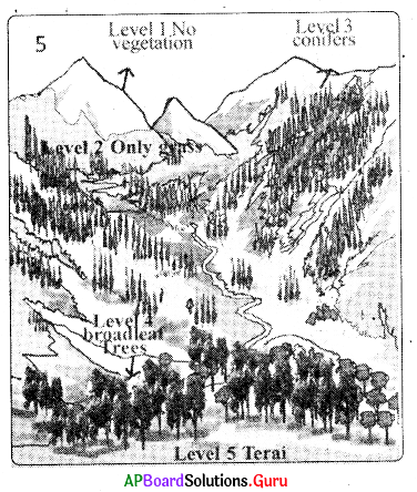
A) At foot hills of Himalayas
B) On mountain peaks
C) On mountain ranges of Himalayas and Shivaliks
D) Western Ghats
Answer:
C) On mountain ranges of Himalayas and Shivaliks
Question 72.
The type of vegetation in Shivaliks /Terai region
A) Grass
B) Coniferous
C) Xerophytes
D) Broad leaf trees
Answer:
D) Broad leaf trees
Question 73.
The hills on the eastern side of India that are at highest elevation in the given map.
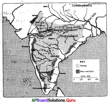
A) Bundelkhand plateau
B) Rajmahal hills
C) Tibetan plateau
D) Chotanagpur plateau
Answer:
B) Rajmahal hills
Question 74.
Identify the physical features that have average elevation of 6000 mts.
A) Tibetan plateau
B) Himalayan peaks
C) Bundelkhand plateau
D) Both A and B
Answer:
D) Both A and B
![]()
Question 75.
The place Where east coast and west coast meets
A) Aroya Konda
B) Rann of Kutch
C) Kanyakumari
D) Nilgiris
Answer:
D) Nilgiris
Question 76.
We find Pirpanjal ranges in …………….
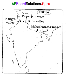
A) Jammu & Kashmir
B) Arunachal Pradesh
C) Punjab
D) Uttar Pradesh
Answer:
A) Jammu & Kashmir
Question 77.
The shape shown resembles
A) Andhra Pradesh
B) Telangana
C) Kerala
D) Tamilnadu
★ Read the following and answer
1. Utkal Coast : This is the northern part It touches Odisha.
2. Circar Coast : This is the middle part. It is the longest coast and touches Andhra Pradesh.
3. Coramandal Coast : This is the Southern Part and touches Tamil Nadu.
Answer:
A) Andhra Pradesh
Question 78.
Utkal, Circar and Coramandal coasts are all part of
A) Bengal Coast
B) West Coast
C) East Coast
D) Rann of Kutch
Answer:
C) East Coast
Question 79.
The state that stands on three seas is …………………
A) Tamil Nadu
B) Karnataka
C) Andhra Pradesh
D) Kerala
Answer:
A) Tamil Nadu
Question 80.
Special feature of Deccan plateau is
A) Red soil
B) Alluvial soil
C) Black soil
D) Laterite soil
Answer:
C) Black soil
Question 81.
Which of the following statements are correct?
I. Central part of Indo-Gangetic plain extends from the rivers Ghaggar to Teesta.
II. This part is mainly spread in the states of Assom and Meghalaya.
A) I and II are correct
B) I and II are incorrect
C) Only I is correct
D) Only II is correct
Answer:
C) Only I is correct
Question 82
…………….. is mainly composed of the old crystalline, hard igneous and metamorphic rocks
A) The Peninsular Plateau
B) Indo-Gangetic Plain
C) Thar Desert
D) All of these
Answer:
A) The Peninsular Plateau
![]()
Question 83.
The eastern and the western most longitudes of India in degrees.
A) 8°4′ and 37°6′
B) 8° and 50°
C) 68°7′ and 97°25′
D) 68° and 90°
Answer:
C) 68°7′ and 97°25′
Question 84.
Tropic of Cancer passes through
A) Bihar
B) Tripura
C) Odisha
D) Nagland
Answer:
B) Tripura
Question 85.
The coast that touches Maharashtra and Goa ………………
A) Konkan
B) Canara
C) Malabar
D) Coramandal
Answer:
A) Konkan
Question 86.
Indira point belongs to ……………….
A) Nicobar Islands
B) Andaman Islands
C) Lakshadweep Islands
D) Pamban Islands
Answer:
A) Nicobar Islands
Question 87.
Andaman and Nicobar Islands are of ……………….. origin.
A) Igneous
B) Coral
C) Volcanic
D) Archanean
Answer:
C) Volcanic
Question 88.
Which is correct?
A) Himalayas are in Southern India
B) Equator is passing through our country
C) India is in Northern Hemisphere
D) India is in between 8° and 37° longitudes
Answer:
C) India is in Northern Hemisphere
Question 89.
Which of the following is the correct statement?
I) Land forms originated from two giant lands namely Angara land and Gondwana land.
II) The Indian peninsula was part of Angara land.
A) I and II are correct
B) I and II are incorrect
C) Only I is correct
D) Only II is correct
Answer:
C) Only I is correct
Question 90.
Coral reefs are found in ………………….
A) Andaman Islands
B) Lakshadweep Islands
C) Western Ghats
D) Nicobar Islands
Answer:
B) Lakshadweep Islands
Question 91.
Utkal, Circar and Coramandal coasts are the parts of the coast ………………
A) Arabian Sea
B) Bay of Bengal
C) Indian Ocean
D) All the above
Answer:
B) Bay of Bengal
![]()
Question 92.
The Shivalik ranges in Arunachal Pradesh are called as …………………
A) Shivaliks
B) Cachar hills
C) Jammu hills
D) Mishmi hills
Answer:
D) Mishmi hills
Question 93.
Tamil Nadu is located near the following latitude ………………….
A) Tropic of Cancer
B) Tropic of Capricorn
C) Equator
D) Arctic Circle
Answer:
C) Equator
Question 94.
This is not the part of East Coast.
A) Utkal Coast
B) Circar Coast
C) Coramandal Coast
D) Canara Coast
Answer:
D) Canara Coast
Question 95.
The land part towards south of Tethys sea is
A) Angara
B) Laurasia
C) Pangea
D) Gondwana
Answer:
D) Gondwana
Question 96.
Among the following states, narrow steep valleys are formed in
A) Goa
B) Jharkhand
C) Gujarat
D) Sikkim
Answer:
D) Sikkim
Question 97.
The rising and setting times of sun are different between Ahmedabad and Imphal. Among the following which is right option for it?
A) India occupies vast area on the globe
B) India is located in Southern and Northern Hemispheres
C) India has the vast extent of latitudinal expansion
D) India lies between 68° 7′ W and 97° 25’E longitudes
Answer:
D) India lies between 68° 7′ W and 97° 25’E longitudes
Question 98.
Which of the following is not the part of the Western Ghats?
A) Anaimalai hills
B) Palakondas
C) Palani hills
D) Cardamom hills
Answer:
B) Palakondas
Question 99.
Which of the following is correct regarding Indo – Gangetic Plain?
A) It was formed 200 million years ago
B) It is formed with black soil
C) It has rich mineral resources
D) River Indus, Ganga and Brahmaputra are mainly responsible for the formation
Answer:
D) River Indus, Ganga and Brahmaputra are mainly responsible for the formation
![]()
Question 100.
Match the following:
1) Canara Coast – a) Tamil Nadu
2) Malabar Coast – b) Kerala
3) Utkal Coast – c) Karnataka
4) Coramandal Coast – d) Odisha
Which is the correct set?
A) 1 – b, 2- c, 3 – d, 4 – a
B) 1 – c, 2 – b, 3 – d, 4 – a
C) 1 – d,2 – b,3 – c,4 – a
D) 1 – c, 2 – a, 3 – d, 4 – b
Answer:
B) 1 – c, 2 – b, 3 – d, 4 – a
Question 101.
The first state to witness sunrise in India is ………………..
A) West Bengal
B) Mizoram
C) Nagaland
D) Arunachal Pradesh
Answer:
D) Arunachal Pradesh
Question 102.
Which is the ancient land block in India?
A) The Himalayas
B) The Indian desert
C) The Indo-Gangetic plain
D) The Peninsular Plateau
Answer:
D) The Peninsular Plateau
Question 103.
Among the following statements, which is not true?
A) The portion of range found south of the Greater Himalayas is known as ‘Lesser Himalayas’
B) Himachal range is mainly composed of highly compressed rocks
C) The Pirpanjal and Mahabharata ranges form the important ranges of the Himachal.
D) The average elevation of Himachal range is about 6,100 mts above MSL.
Answer:
D) The average elevation of Himachal range is about 6,100 mts above MSL.
Question 104.
The Tropic of Cancer does not pass through
A) Tripura
B) Rajasthan
C) Chattisgarh
D) Odisha
Answer:
D) Odisha
Question 105.
Which of the following hills are not a part of Purvanchal?
A) Patkai
B) Naga
C) Mizo
D) Nilgiris
Answer:
D) Nilgiris
Question 106.
Among the following statements, which is not true?
A) The portion of range found south of the Greater Himalayas is known as “Lesser Himalayas”
B) Himachal range is mainly composed of highly compressed rocks
C) The average elevation of Himachal range is about 6,100 mts above MSL.
D) The Pirpanjal and Mahabharata ranges form the important ranges of the Himachal.
Answer:
C) The average elevation of Himachal range is about 6,100 mts above MSL.
Question 107.
It is not the border of Deccan plateau
A) Satpura range
B) Aravalis
C) Eastern ghats
D) Nilgiri Hills
Answer:
B) Aravalis
![]()
Question 108.
Geographical area of Lakshadweep.
A) 324sq.km
B) 32sq.km
C) 32 lakh sq.km
D) 3 sq. km
Answer:
B) 32sq.km
Question 109.
“Marshy Tract” is called
A) Bhabar
B) Terai
C) Bhangar
D) Khadar
Answer:
B) Terai
Question 110.
This mountain range is not situated in the Himalayas
A) Everest
B) Annapooma
C) Dodabetta
D) NandaDevi
Answer:
C) Dodabetta
Question 111.
This is the source of the perennial rivers in India
A) High rainfall in Deccan plateau
B) Accumulation of ice, movement and melting of glaciers
C) Born in western ghats
D) Retreating monsoons
Answer:
B) Accumulation of ice, movement and melting of glaciers
Question 112.
Lakshadweep islands are famous for
A) Variety of flora and fauna
B) Volcanic eruptions
C) Nicobar birds
D) Variety of minerals
Answer:
A) Variety of flora and fauna
Question 113.
This part of India lies in the Tropical belt.
A) Eastern part
B) Western part
C) Northern part
D) Southern part
Answer:
D) Southern part
Question 114.
Shivalik series are regionally called …………..
A) Jammu Hills
B) Mishmi hills
C) Cachar
D) All of the above
Answer:
D) All of the above
![]()
Question 115.
Patkai hills are the part of
A) Himadri
B) Himachal
C) Shiwaliks
D) Purvanchal
Answer:
D) Purvanchal
Question 116.
Mahadev hills are a part of
A) Vindhyas
B) Aravalis
C) Satpura ranges
D) Western ghats
Answer:
C) Satpura ranges
Question 117.
The mountain ranges that separate North India from South India
A) Vindhya – Satpura ranges
B) Aravali mountains
C) Himalayas
D) Nilgiris
Answer:
A) Vindhya – Satpura ranges